

History

1870
Col. Charles Mathewson and his two sons, Charles and Joseph, built the Sugar City Cereal Mill along the North Fork River at Norfolk Avenue and State Street, which is now First Street. The mill served as a sawmill and gristmill, as well as one of Norfolk’s first general stores and its first post office for the first settlers that arrived in Norfolk in 1866.

1900's
In the early 1900’s youth used the river as a swimming hole below the Norfolk Mill dam. Throughout the 1900s, many community groups and citizens have used Johnson Park for various picnics and gatherings.
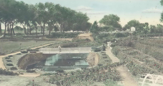
1937
Johnson Park is developed through a Works Progress Administration (WPA) project during the Great Depression. The park was the project of Nels P. Johnson, chairman of the Norfolk Park Board.
1937 - 1961
Norfolk experiences six major floods and eleven minor floods because of the waters from the North Fork of the Elkhorn River. One of the worst floods occurred on May 12, 1944, when pilots flying over the city estimated the water covered an area 1½ miles wide. The next major flood came in March 1962 when spring rains and warm weather caused ice jams in the rivers. Ninety city blocks, including 50 percent of the business district, was flooded.
1962
In May 1962, city officials agreed to work with the Army Corps of Engineers on a flood control project. By October of that year, the council had chosen among four designs proposed by the Corps. Funding for the $4.25 million project (around $30 million today) came from the city and the federal government.

1966 - 1968
Construction of the flood control channel began in the spring of 1966. The system was built to withstand twice the amount of water a 100-year flood would impose on the city. The project was completed in late 1968 and was put to the test the following spring when “conditions remarkably similar” to those preceding the 1944 flood occurred. The 4.5-mile canal starts north of Norfolk at Highway 81 and continues south of Omaha Avenue.
1974
The City of Norfolk and a team of consultants with specialties in planning, landscape architects and river engineering collaborated to develop a Master Plan for Johnson Park and the restoration of the section of the North Fork adjacent to Johnson Park.
1990 - 1995
Efforts to revive the vision of creating a riverfront project resurface with collaboration between the City of Norfolk, Elkhorn Recourses District, and Norfolk Sanitary Drainage District. The project envisioned was a six-mile redevelopment area. At the time, approximately 73% of citizens surveyed indicated a need for more public recreation.
2008
Lonn Atwood a local artist and previous Mayor, Jim Miller sparked renewed interest in the “River Walk” by holding public forums at different locations. A number of those attending spoke highly of the idea including Norfolk’s Mayor Dr. Gordon Adams and Stan Staab who served as General Manager of the Lower Elkhorn NRD. The Riverfront Development Group began holding monthly meetings and raised over $86,000 from businesses, organizations and citizens. They used a portion of the money to hire HDR Engineering for the first two phases of the Riverwalk Master Plan and unveiled the project logo that had been selected through a competition of 47 logo submissions.
2009
Over 60 individuals are interviewed by HDR through a series of 12 sessions to complete the first phase of master plan. Supporters and those interested in learning more about the NorthFork Development project participated in a tour to envision development possibilities.
2011
The National Parks Service awards Norfolk a developmental assistance grant to help with research, development and planning for whitewater kayaking and tubing along the North Fork of the Elkhorn River. The involvement of the National Parks Service led to the creation of the overlay district along the river and solidified the concept of using the river itself as a recreational trail.
2012
The Riverwalk Board of Directors voted unanimously to purchase approximately 800 lime stones from Ken Porter Construction to donate to the City of Norfolk for use along the North Fork River near downtown. The stones were salvaged from the demolition of a historic building at Norfolk’s Regional Center. The stones are currently being stored by the city.
2015
The Nebraska Games and Parks Commission awarded a $561,373 grant to fund the Johnson Park Trail project. As part of the Johnson Park revitalization plan, Nebraska Avenue, which goes through the park, was closed. The plan also calls for adding berms and landscaping to allow visitors to get closer to the river.
2017
Mayor Moenning, city administrator Andy Colvin, city engineer Steven Rames, and Mike Sousek who serves as general manager for the Lower Elkhorn Natural Resources District began attending the monthly Riverfront Development meetings.
2018
Members of the City Council approved and established an “Overlay District” along the North Fork of the Elkhorn River from Norfolk Avenue to Elm Street to set guidelines for new construction along the river, in an effort to keep construction designs consistent with the vision for the area.
2018
The Lower Elkhorn Natural Resources District board of directors votes 8-5 to provide $1,032,000 over four years for the North Fork River restoration. This will cover one-third of the $3 million project, with the other two-thirds coming from the private sector and a source identified by the City of Norfolk.
2019
Norfolk City Council voted unanimously to approve a design contract with Riverwise for the North Fork River Restoration Project. The City of Norfolk is currently working with JEO Consulting Group, Inc., Riverwise Engineering LLC, and Big Muddy Workshop to master plan the North Fork Riverfront Development project.
The project includes:
- The redevelopment of the North Fork River to include eight, whitewater drop points
- The restoration of Johnson Park to include community festival space and the incorporation of an amphitheater
- The replacement of the 1st Street bridge to incorporate an underpass trail.
2022
First Street Bridge Replacement with Underpass Trail System & Roundabout Integration
In order to optimize the improvements made to the North Fork River and Johnson Park, an evaluation of the existing bridge on First Street was done to ensure safety and connectivity, which is paramount to the overall plan. The existing bridge is defined as a “box culvert” that if left, would leave obstacles in the river impairing safety and navigability for future water users. A complete replacement of the existing bridge was needed to remove the concrete obstacles within the river, as well as create a trail underpass thereby removing the dangers pedestrians encounter with the current at grade traffic crossing. Additionally, in order to reduce traffic speeds, promote pedestrian safety, and provide further interconnection to the area, the North Fork Development Project included the introduction of a roundabout at First Street and Braasch Avenue.